
Temporary closure of Smoo Cave near Durness
22nd September 2013
The Highland Council has appointed Rope Access Scotland Ltd to undertake rock stability works in the vicinity of Smoo Cave near Durness in Sutherland. The work, which commences on Monday September 30th and is expected to take two weeks to complete, includes light rock scaling, netting and bolting and will be overseen by geotechnical experts from consultants URS Infrastructure & Environment UK Limited.
For the duration of the works both the cave and paths down to the cave will be closed for public access. The eastern path to the headland and the bridge over the waterfall will be kept open except for short periods when work is taking place immediately adjoining or underneath. For their own safety, visitors are requested to follow all instructions provided on site.
The cave and its immediate environs are in the ownership of Highland Council and managed by the Planning and Development Service for the purpose of countryside recreation. Visitor numbers to the site are in excess of 43,000 per annum.
Vice Chairman of the Council's Planning, Environment and Development Committee Councillor George Farlow said: "The works proposed are essential for the site to be maintained in a safe condition so we can continue public access to the cave so I am glad to see a date for the job has been set. The Council's ownership and management of Smoo Cave directly supports our economic development objective to delivery a quality tourism product in this remote and fragile area. Smoo Cave is a key site in terms of both archaeology and geology and has a unique contribution to make within the North West Sutherland Geopark. The provision of quality countryside recreation also supports the Council's commitment to strong, healthy communities. "
Wikipedia Description Of Smoo Cave
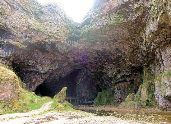
The cave is unique within the UK in that the first chamber has been formed by the action of the sea, whereas the inner chambers are freshwater passages, formed from rainwater dissolving the carbonate dolostones. Partway through the cave the waters of Allt Smoo also drop in as a 20m high waterfall. This is mainly due to the nearby dolostone - quartzite geological boundary where the Allt Smoo stream crosses the impermeable quartzites and sinks on meeting the permeable dolostones. Essentially the cave can be thought of as two caves formed by different mechanisms which have joined together over time. The cave is composed of three main sections; a large sea cave entrance chamber, a waterfall chamber and a short freshwater passage which leads to a terminal sump chamber with some interesting flowstone formations at the rear.
The cave entrance and main chamber have been considerably enlarged by sea action to approximately 40m wide and 15m high, the largest sea cave entrance in Britain. The entrance is located at the end of a 600m long tidal gorge (Geodha Smoo) which was once part of the cave, now collapsed. Several remnant pillars can be seen along the eastern side of the Geodh along with a large section of the previous roof which has been partly buried by the grassy slope (normally covered by rocks spelling out the names of visitors to the cave). Interestingly, the sea rarely enters the sea cave nowadays (only during spring tides) as the area has undergone isostatic uplift.
The present-day cave is 83m long up to the terminal sump at the rear of the third chamber / passage. The cave travels further however as an active stream of notable size resurges here at all times. Previous dye-testing has linked an underwater passage to an initial sink point in the Allt Smoo stream about 100m upstream from the main waterfall, implying that the cave system is at least twice as long as once thought. Cave divers belonging to the Grampian Speleological Group have dived this sump to a distance of c. 40m, although large volumes of silt and peat in the water have prevented further exploration. It is worth noting that the main waterfall is often dry and will only become active once this upstream sink overflows.
Archaeological investigations have turned up Neolithic, Norse and Iron Age artifacts, and it is thought that usage may extend back to the Mesolithic age. The cave name is thought to originate from the Norse 'smjugg' or 'smuga' meaning a hole or hiding-place.